
Dec. 27, 2019
Mexican archaeologists have just recently revealed the remains of a vast Mayan palace, that’s over 1,000 years old. This big Maya palace is just one part of the ancient city of Kulubá, roughly 100 miles west of Cancún, in Northeast Yucatán.
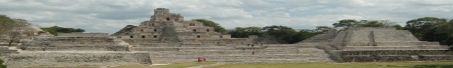
The Kulubá palace’s form is somewhat unique (see the foto below) …
It’s dimensions: 55 meters long, 15 meters wide, but just 6 meters high. Overall, the palace consisted of just six big rooms. The Kulubá palace is one part of a larger complex that also includes two residential rooms, an altar and a large round oven.

The Kulubá palace & the site are somewhat unique, because it bridges 2 Yucatec Maya epochs. The palace was in use during the Yucatec Mayas late classical period (600 AD – 900 AD), through the terminal classical (850 AD – 1050 AD) between AD850 and AD1050, per award-winning Yucatecan archeologist & lead archeologist director Alfredo Barrera Rubio.

Per Rubio:
“We know very little about the architectural characteristics of this region, the north-east of Yucatán. So one of our main objectives, as well as the protection and restoration of cultural heritage, is the study of the architecture of Kulubá. ”

“… This is just the start of the work. We are only just uncovering one of the largest structures on the site.” Rubio hopes that as the work continues, Kulubá “will become a natural attraction for visitors to the region.”

Specifically, the Kulubá site lies midway between Tizimin & Kantunkin … off the Tixcancal road.
This link takes you to a map:
https://www.google.com/maps/place/Ruinas+de+Kuluba/@21.1161301,-87.8465939,15z/data=!4m5!3m4!1s0x0:0x7e465de2013985af!8m2!3d21.1161301!4d-87.8465939

Check out the official INAH fotos here:
* * * *
Feel free to copy while giving proper attribution: YucaLandia/Surviving Yucatan.
© Steven M. Fry
Read-on MacDuff . . .

Wow!!
The first photo looks a good deal like the plaza building at Ek Balam. The last photo of the monster mask looks like one that was looted from Coba in the late 80s. The next question is: Are there limestone roads between the three ruins?
Hmmm… a map of the Sac Be’s would be a fun & useful tool …
http://www.famsi.org/reports/98027/98027Mathews01.pdf ??
??? Kulubá and other sites not present on this map …
http://www.mayamap.org/