
Do you enjoy shifting your perspectives?
Consider how the maps of Merida have changed over time.
How many readers have believed the many past supposed “old” maps of Merida that show Merida’s Plaza Grande (aka “Plaza Principal” or “Zocalo”) as being bordered by “Calle 60”, “Calle 62” and “Calle 61” & “Calle 63” ?
I never bought that … because when Merida Centro was laid out in 1542, it’s clear the founders never imagined a big 30 block by 30 block Centro region … which always made the so called “old” maps of Merida, with their “Calle 60”, “Calle 62” and “Calle 61” & “Calle 63” bounding the center of Merida seem more than a bit specious to me.
In a fun find this morning, I finally encountered an official “Plano Grafico de la Ciudad de Merida” (1864) … that has the earlier ACTUAL names of the streets of Merida.
The smaller map shown below is a closeup of an official 1864 map of the center of Merida.
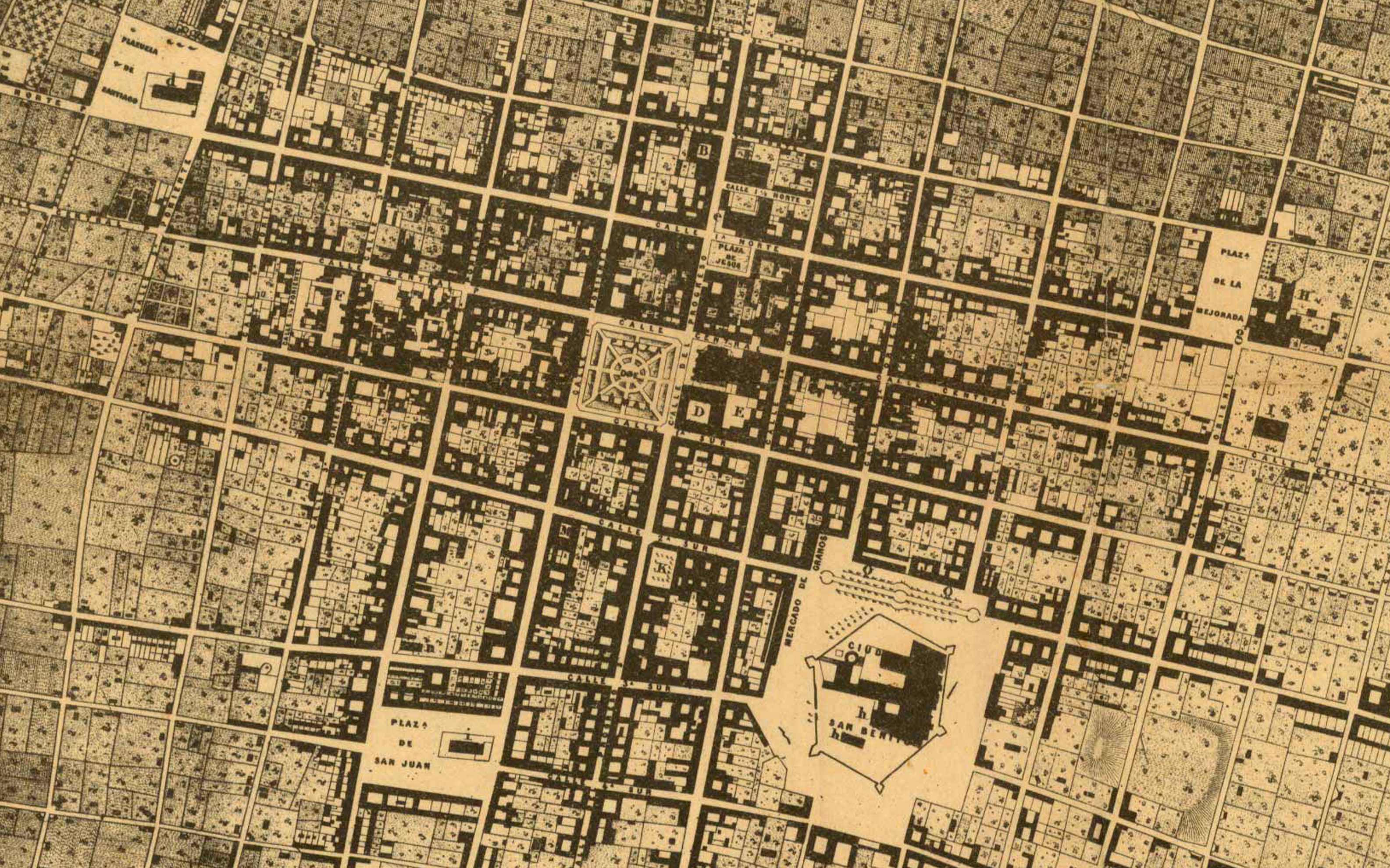
One thing that jumps out right away is that the so-called “Plaza Grande” is actually named “Plaza de Armas” on this map.
The next fun things that pop-out are the street names around the center of Merida … Starting from North to South … (top to bottom)
~ Calle Central … North side of the Plaza de Armas (“Plaza Grande”)
~ Calle 1A Sur … South side of the Plaza de Armas
~ Calle 2A Sur … The 2’nd street south of the Plaza de Armas
~ Calle 3A Sur … The 2’nd street south of the Plaza de Armas
~ Calle 4A Sur … The 2’nd street south of the Plaza de Armas
= = = =
Notice how the whole Calle Par (even) & Calle Impar (odd) street naming system is a quite ~MODERN~, quite recent imposition of street names … along with the whole MODERN “Calle 60”, “Calle 62” and “Calle 61” & “Calle 63” naming convention of the streets around Merida Centro …
= = = =
Then notice the fun street names going out East and West of the Plaza de Armas (“Plaza Grande”):
Naming them from West to East (right to left)
~ Calle 5A Poniente … aka “Calle 70” today
~ Calle 4A Poniente … aka “Calle 68” today
~ Calle 3A Poniente … aka “Calle 66” today
~ Calle 2A Poniente … aka “Calle 64” today
~ Calle 1A Poniente … aka “Calle 62” today
… Plaza de Armas … aka “Plaza Grande” today …
~ CALLE DEL PROGRESO … “Calle 60” today
~ Calle 1A Oriente … aka “Calle 58” today
~ Calle 2A Oriente … aka “Calle 56” today
~ Calle 3A Oriente … aka “Calle 54” today
and so on, and so on.
= = = =
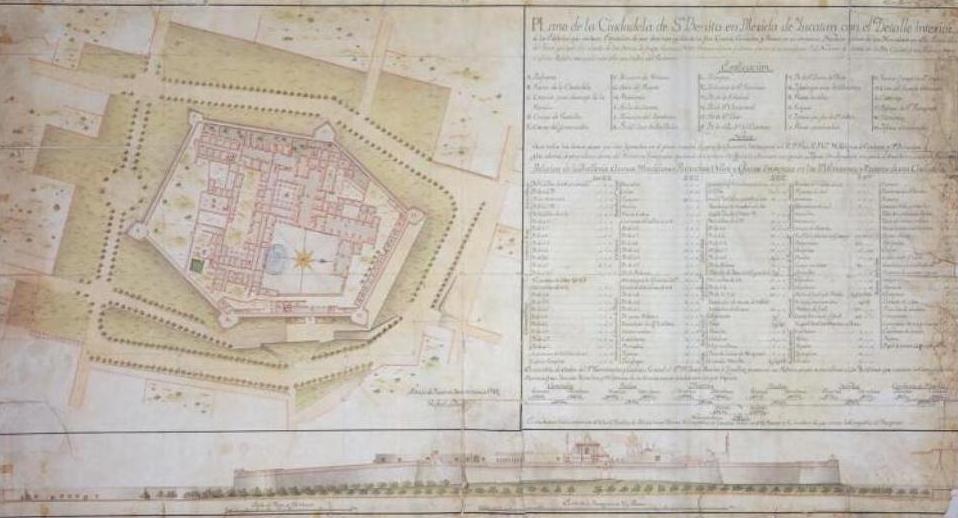
Then … Notice the big curious FORT … “Ciudadela de San Benito” that was smack dab where we experience the supposed “old market” of todays “Mercado Lucas de Galvez ” … and today’s supposed “new Mercado San Benito” …
For more details on Merida Centro’s fort, check out the 1788 Plano-map (below) of the “Ciudadela de San Benito” fort … that was built next to the 1537 Convento de San Francisco – that had been built on Merida Centro’s “cerro de San Benito” … “San Benito Hill”.
= = = =
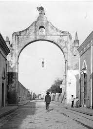
Finally, to get an even more full picture of Merida in the 1860’s … Imagine 9 big Arcos (Arches) at that time … (1864-1865)**
2 in the West: “Arco El Caído” (C61 y C70) & “Arco de Nuestra Señora de La Concepción Truncado” also called “Arco Xcul” (C63 y C70).
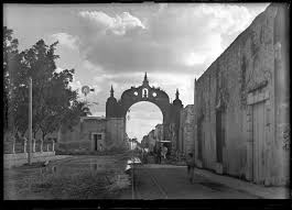
Then … 2 in the East: “Arco de Dragones” (C61 y C50) & “Arco del Puente” (C63 y C50).
Arco de Dragones is seen here:
Then … 1 in the North … “Arco de San José” (C53 y C62).
2 in the South … “Arco de San Juan” (C64 y C69-A) & “Arco de San Cristobal” (C62 y C69-A).
Arco de San Juan is seen here:
and finally, one close to the Cathedral, “Arco del Semina Rio” (C53 y C58)
This information is courtesy of Arquilogo D. Luis Millet Camara
= = = =
Here’s a somewhat crude but fun image of the locations 9 Arcos of Merida in 1864
Courtesy of YucatanAncestral.com … See more here:
https://yucatanancestral.com/xcul-arco-merida-yucatan/?fbclid=IwAR3pyOYG2Vq4H1U05SQWTfZX-AFeABt-9EDFGkVkD9ZMeWV0MAGNi_hSstw
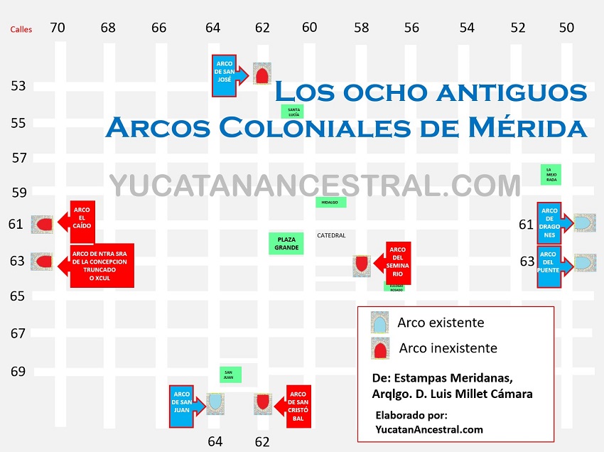
**Note that Arcos have come & gone since 1560, with a peak of 13(?) arches, that included many TRIUMPHAL arches that no longer exist …
and yes, we plan to publish more details in the future.
Cheers,
Dr. Steven M. Fry
* * * * * * *
Feel free to copy any of our materials, yet please also give appropriate credit, by citing Yucalandia.com.
Read On … MacDuff !

If you could get to the bottom of the pueblos’ central streets almost always being 21, with the occasional 20, 22, or 23, it would be appreciated by some of us out here.
Thanks for this history if Metida’s past. A thing that had fascinated me, and has been difficult to trace.
I understand that it’s as simple as the Spanish town planner-founders anticipated towns of just 20 block by 20 block dimensions.
As you pop around rural Yucatan & Campeche and rural Q. Roo, that formula works for a whole lot of towns.
???